

Newsroom
-
 Deep Learning Technology Enables Terahertz Security Inspection More Accurate and Faster
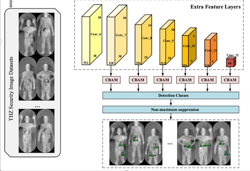
A research team led by Prof. FANG Guangyou from the Aerospace Information Research Institute (AIR), Chinese Academy of Sciences (CAS) trained and tested a promising detector based on deep residual networks using human image data collected by passive terahertz devices (Figure 1a, b, c). The proposed new method can be used for accurate and real-time detection of hidden objects in terahertz images. The study was published in Scientific Reports.
22 Jul 2022 -
Book Series "BeiDou Navigation Satellite System" Compilation Underway
An editorial committee meeting was held in Beijing on July 1, 2022, marking the inauguration of compilation of the book series BeiDou Navigation Satellite System (BDS) , which aim to wrap up how the BDS was constructed in China as well as its achievements.
17 Jul 2022 -
 Scientists Propose Flexible THz Carrier-Envelope Phase Shifter Based on Metamaterials
A research team led by Prof. WANG Tianwu from the Aerospace Information Research Institute (AIR), Chinese Academy of Sciences (CAS) proposes an ultra-thin THz CEP shifter composed of different MM arrays, which can modulate the CEP of broadband THz pulses in the sub-wavelength thickness range and maintain the electric field polarization (Figure 1a, b). The study was published in Advanced Optical Materials.
14 Jul 2022 -
 Datasets Unveil Impacts of Land Use and Cover Change on Sahel in Africa
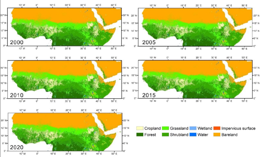
Four datasets on the Sahel-Sudano-Guinean region of Africa have been recently released on the platform of the National Tibetan Plateau / Third Pole Environment Data Center. The four datasets include: 1) 30m resolution land use/cover the (1990-2020); 2) annual NPP-VIIRS (National Polar-Orbiting Partnership - Visible Infrared Imaging Radiometer Suite) night time light (2013-2020); 3) long time series on night time light on the same region as data set (2), but a much longer period of time (1992-2020); 4) inventory and extent of surface water bodies (2000-2020).
06 Jul 2022 -
 Impact Factor of Microsystems & Nanoengineering Rises to Record-high 8.006
According to the 2022 Journal Citation Report (JCR) recently released by Clarivate Analytics, the impact factor of Microsystems & Nanoengineering has risen to 8.006 in 2021. With a 50% increase in the total number of articles published, Microsystems & Nanoengineering has ranked No. 4 in the Instrument & Instrumentation category in JCR in terms of impact factor, continued to be ranked in the Q1, and ranked No. 1 in instrumentation subject in Chinese journals for six consecutive years.
06 Jul 2022 -
 Program on Intelligent Processing of Big Point Cloud Data Launched
A program on "Key technologies and software for intelligent processing of multi-platform and multi-modal point cloud data" was launched to develop key technologies and software for intelligent processing of big point cloud data.
12 Jun 2022

