Chinese Scientists Release High-resolution Rice Map of Africa to Support Global Food Security
A research team from the Aerospace Information Research Institute (AIR) of the Chinese Academy of Sciences (CAS) released Africa's first high-resolution rice distribution map at 20-meter resolution. This 2023 dataset, published in Earth System Science Data, offered full coverage of African countries with national-level rice cultivation areas exceeding 5,000 hectares.
This study, titled "The 20m Africa rice distribution map of 2023", demonstrates an average classification accuracy exceeding 85% and a linear correlation (R²) above 0.9 with national statistics. The dataset is now openly accessible to the global research community, and is expected to play a key role in supporting the monitoring and evaluation of the United Nations Sustainable Development Goal 2 (SDG2) on zero hunger.
As the third most important staple crop in Africa, rice plays a strategic role in ensuring regional food security. Despite contributing only 4.7% to global rice production, Africa's rice demand is growing at an annual rate exceeding 6%, outpacing other staple crops. In response to this rising demand, African countries have expanded their cropland by an average of 400,000 hectares annually over the past three decades.
In 2023, the Africa Rice Center launched the "2030 Africa Rice Research and Innovation Strategy" to transform the rice-based agricultural food system and promote further rice cultivation. However, rice cultivation in Africa faces numerous challenges. It is highly vulnerable to climate change impacts, including extreme weather events, changing precipitation patterns, and rising temperatures, as well as land use changes like urban expansion and deforestation. These factors underscore the urgent need for high-resolution spatial data for Africa to monitor the rice cultivation dynamics over the continent.
Mapping rice in Africa presents unique challenges. The continent's tropical and subtropical climate leads to complex and various rice planting seasons. Moreover, the dominance of rainfed rice cultivation—which lacks the clear flooding signals typically found in irrigated rice—makes phenology-based rice mapping methods difficult to apply in the region. As a result, integrating time-series data with supervised classification has become the main strategy for mapping rice distribution across Africa. Existing rice distribution products for Africa are low-resolution (coarser than 5 km), making it difficult to identify rice-growing areas for sample collection. Variability in terrain, cultivation practices, and planting intensity further complicates accurate mapping.
To overcome these barriers, the research team developed an innovative approach combining dual-polarimetric SAR backscattering features with machine learning algorithms. The framework — "backscatter-based coarse localization followed by multi-source time-series refined classification" — enables precise mapping in areas with diverse planting cycles and rainfed systems. The team also proposed an object-oriented feature importance classifier, advancing beyond traditional optical techniques.
This study was led by PhD student JIANG Jingling at AIR, with Professor ZHANG Hong serving as the corresponding author. The resulting dataset is expected to support food security policy, agricultural research, and SDG monitoring efforts across Africa and beyond.
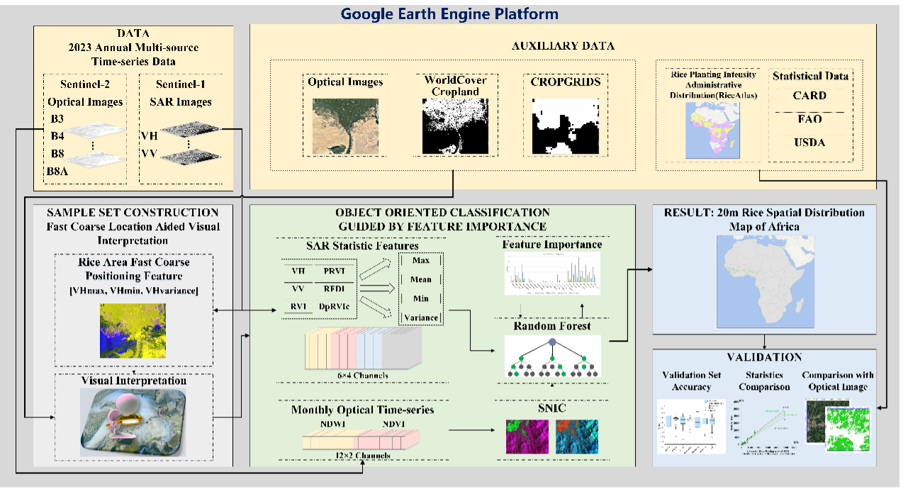
Flowchart of the proposed rice-mapping method. (Image by AIR)
News & Events